http://sst.rncan.gc.ca/ercc-rrcc/theme1/t9_e.php
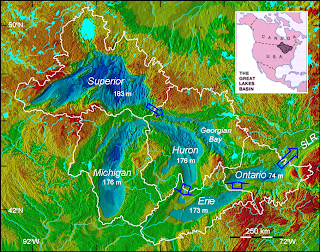
A Digital Elevation Model (DEM) is a type of topographic or terrain map. Many DEMs are shown as a grid of squares or raster. The data used to make a DEM are usually compiled using remote sensing. The DEMs are made by using regularly spaced elevation values which are tied-in horizontally either to a Universal Transverse Mercator (UTM) projection or to a geographic coordinate system. The U.S. Geological Survey (USGS) makes five main types of elevation data: 7.5-minute DEM, 30-minute DEM, 1-degree DEM, 7.5-minute Alaska DEM, and 15-minute Alaska DEM. According to the USGS they are no longer offering Digital Elevation Models as of November 2006. The DEM above is of the Great Lakes region and is a UTM projection. The purpose of this DEM is to demonstrate lower water elevations due to climate change.

No comments:
Post a Comment